ၾၢႆႇ:England locator map with North East England highlighted.svg

Size of this PNG preview of this SVG file: 494 × 600 ၽိၵ်ႉသႄႇလ်. resolutionsတၢင်ႇဢၼ် : 198 × 240 ၽိၵ်ႉသႄႇလ် | 395 × 480 ၽိၵ်ႉသႄႇလ် | 632 × 768 ၽိၵ်ႉသႄႇလ် | 843 × 1,024 ၽိၵ်ႉသႄႇလ် | 1,686 × 2,048 ၽိၵ်ႉသႄႇလ် | 816 × 991 ၽိၵ်ႉသႄႇလ် ။
ၾၢႆႇငဝ်ႈတိုၼ်း (ၾၢႆႇ SVG, ၸိုဝ်ႈ 816 × 991 pixels, သႅၼ်းၾၢႆႇ : 469 KB)
| ၶေႃႈသပ်းလႅင်း |
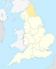
English: Equirectangular projection of England; North East England is highlighted. |
| ဝၼ်းထီႉ | |
| ငိူၼ်ႈငဝ်ႈတိုၼ်း | File:England location map.svg |
| ၽူႈတႅမ်ႈလိၵ်ႈ | |
| ၶေႃႈလူတ်းပွႆႇ (ၶိုၼ်းၸႂ်ႉ ၾၢႆႇဢၼ်ၼႆႉ) |
ၾၢႆႇဢၼ်ၼႆႉၼႆႉ မီးသုၼ်ႇဝႂ် ပႃႈတႂ်ႈ ၶွင် Creative Commons Attribution-Share Alike 3.0 Unported ဝႆႉၼႆႉ။
|
ပိုၼ်းၾၢႆႇ
တဵၵ်းၼိူဝ် ဝၼ်းထိ/ၶၢဝ်းယၢမ်း တႃႇႁၼ်ၾၢႆႇ ၼႂ်းဝၼ်းၼၼ်ႉ
| ဝၼ်းထီႉ/ၶၢဝ်းယၢမ်း | ႁၢင်ႈလဵၵ်ႉ | သႅၼ်းမၼ်း | ၽူႈၸႂ်ႉတိုဝ်း | တၢင်းႁၼ်ထိုင် | |
|---|---|---|---|---|---|
| ယၢမ်းလဵဝ် | 09:34, 8 ဢေႇပရႄႇ 2010 | | 816 × 991 (469 KB) | Jappalang | {{Information |Description=Equirectangular projection of England; Northumberland is highlighted |Source=File:England location map.svg |Date=2010-04-08 |Author=* File:England location map.svg: Spischot * author: [[User:Jappalang |
လွင်ႈၸႂ်ႉတိုဝ်း ၾၢႆႇ
2 ၼႃႈလိၵ်ႈ ၵွင်ႉမႃးၸူးၾၢႆႇၼႆႉ:
လွင်ႈၸႂ်ႉတိုဝ်းၾၢႆႇလူမ်ႈၽႃႉ
Wikis ၸိူဝ်းဢၼ်ၸႂ်ႉဝႆႉ ၾၢႆႇဢၼ်ၼႆႉ:
- ၸႂ်ႉဝႆႉ am.wikipedia.org
- ၸႂ်ႉဝႆႉ ar.wikipedia.org
- ၸႂ်ႉဝႆႉ as.wikipedia.org
- ၸႂ်ႉဝႆႉ bh.wikipedia.org
- ၸႂ်ႉဝႆႉ blk.wikipedia.org
- ၸႂ်ႉဝႆႉ bn.wikipedia.org
- ၸႂ်ႉဝႆႉ bs.wikipedia.org
- ၸႂ်ႉဝႆႉ ca.wikipedia.org
- ၸႂ်ႉဝႆႉ cy.wikipedia.org
- ၸႂ်ႉဝႆႉ da.wikipedia.org
- ၸႂ်ႉဝႆႉ diq.wikipedia.org
- ၸႂ်ႉဝႆႉ dty.wikipedia.org
- ၸႂ်ႉဝႆႉ en.wikipedia.org
- Template:Location map+
- Template:Location map~
- Template:Location map+/doc
- Template:Location map+/sandbox
- Template:Location map+/testcases
- Template:Location map~/sandbox
- Template:Location map+/AlternativeMap
- User:Arjunaraoc/sandbox/SampleMap1
- User:Arjunaraoc/sandbox/SampleMap2
- User:Arjunaraoc/sandbox/SampleMap3
- ၸႂ်ႉဝႆႉ en.wikibooks.org
- ၸႂ်ႉဝႆႉ en.wikiversity.org
- ၸႂ်ႉဝႆႉ fa.wikipedia.org
တူၺ်း ၾၢႆႇmore global usage ဢၼ်ၼႆႉ